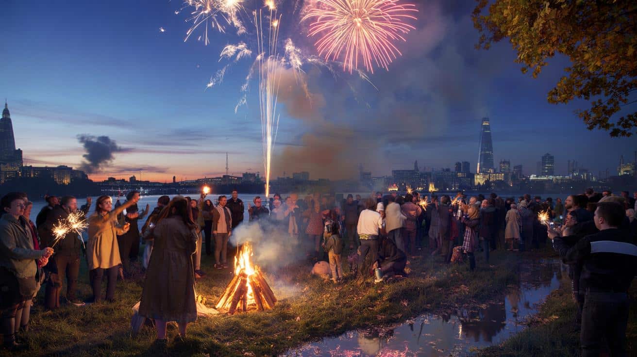
New model runs point to a short, mild pulse building from the south-east at the start of next month, lining up with Bonfire Night. The signal is strongest across East Anglia and the Home Counties, with warmer air set to spill further north and west for a day or two.
Maps point to a Bonfire Night bump
Computer guidance used by forecasters shows a window around Tuesday 5 November when parts of England could nudge 18C. The plume looks most convincing for Norfolk, Suffolk and Essex, with London and Kent not far behind near 17C. If the timing holds, the evening’s fireworks may crackle under skies that feel more late September than early November.
Tuesday 5 November currently stands out: East Anglia tops the table near 18C, with London, Kent and Hertfordshire close behind around 17C.
These values sit several degrees above the seasonal norm. Early November daytime averages typically reach 11–12C across East Anglia, 12–13C in London, and closer to 9–10C in parts of Cumbria. A brief warm spell would not break records, yet it would feel striking after a run of blustery, wet days.
Who gets the warmth, and who misses out
The warmest air tracks the east and south-east. Western coasts look cooler and breezier with nearby low pressure still active in the Atlantic. Here’s how the snapshot currently lines up for Tuesday 5 November based on the latest data:
| Region | Forecast max | Feel |
|---|---|---|
| Norfolk, Suffolk, Essex | 18C | Mild, brighter spells, light winds inland |
| London, Kent, Hertfordshire, Cambridgeshire | 16–17C | Mild, some cloud, lighter showers |
| Midlands, Yorkshire, north-east England | 14–16C | Temperate, breezy at times |
| Merseyside, Lancashire | 14C | Cloudier, spots of rain |
| Cumbria | 10C | Cool, hill fog and drizzle |
| Devon | 15C | Bright intervals, onshore breeze |
| Cornwall | 13C | Windier, showers near coasts |
Confidence grows when multiple runs repeat the same signal. The eastern tilt in the warmth appears consistently, helped by lighter winds and a short-lived southerly feed. Western areas look shackled to fronts spinning in from the Atlantic, holding temperatures down and keeping showers in play.
Why an ‘Indian summer’ signal shows up in November
The phrase Indian summer describes an unseasonably mild spell after the first chill of autumn. In the UK it usually needs three ingredients: a push of warmer air from the south, high pressure close enough to settle the wind, and a gap between Atlantic systems. In this case, numerical models suggest a narrow ridge builds over the near Continent and nudges across eastern England for 24–48 hours.
That ridge would funnel milder air towards East Anglia and the south-east, raising daytime highs into the mid to upper teens. The west stays closer to low pressure, so thicker cloud and patchy rain cap the temperatures there. Any sunshine would further boost readings in the east, particularly in urban pockets such as central London and Chelmsford.
Think of it as a weather truce: a brief ridge squeezes in between Atlantic lows, allowing temperatures to jump 4–6C above par in the east.
The broader pattern through early November
Long‑range guidance from national forecasters keeps a changeable theme for 30 October to 8 November. A vigorous start brings bands of rain and strong gusts, with the west taking the wettest hits. After that, low pressure remains nearby, so the UK faces more spells of wind and rain, punctuated by brighter windows. Temperatures trend close to, or a touch above, the seasonal average through the period.
That means the mild spike around Bonfire Night could sit between unsettled days either side. The window may shift earlier or later by a day as fresh data arrives. If the ridge tightens, the mild pocket can expand. If Atlantic fronts arrive faster, the warmth gets squeezed east into the North Sea.
What it means for your plans
- Bonfire Night gatherings: eastern counties look mild and often dry, but carry a light jacket for late‑evening chill.
- Commuting and school runs: western routes face wet roads and gusts either side of the 5th, so plan extra time.
- Coastal walks: Cornwall and Devon stay cooler with onshore winds; seek sheltered coves for a calmer feel.
- Gardens and allotments: milder air slows frost risk in the east, yet clear skies overnight can still trigger ground frost inland.
- Air quality and fog: light winds may allow morning mist and pockets of fog in valleys across the east and Midlands.
How unusual is 18C in early November?
It isn’t unprecedented, yet it remains noteworthy. Early November highs near 18C in East Anglia sit 5–7C above the long‑term average. Local microclimates can add another degree or two in built‑up areas. Night‑time values, though, still drop quickly under clear skies due to longer nights, so fireworks spectators should expect a marked temperature dip after sunset.
Key risks to watch this week
Short‑range forecasts can shuffle details at 24–48 hours. Keep an eye on:
- Frontal timing from the Atlantic that can undercut the warm sector and bring rain sooner.
- Cloud amounts in the east; thicker cloud trims the peak by 1–2C, sunshine boosts it.
- Sea breezes on the East Anglian coast that shave a degree off inland highs.
- Evening fog formation after a mild, calm day, which can reduce visibility for events and late travel.
Practical snapshot by area for 5 November
East Anglia: Norwich, Ipswich, Bury St Edmunds, Colchester and Chelmsford line up as the warmest spots, with inland sites favoured for the top readings. London and the Thames corridor also sit in the warm zone, with mid to high teens likely. Central England, including the Midlands and Yorkshire, looks set for temperate mid‑teens, breezier on high ground. North‑west England leans cooler and cloudier, with 14C around Merseyside and Lancashire, dropping to near 10C across Cumbria. The south‑west divides: Devon may catch 15C inland, while Cornwall holds closer to 13C with more wind exposure.
Extra context to build the bigger picture
Weather maps widely shared online often stem from a single model snapshot. They offer useful guidance, but they can over‑emphasise sharp peaks. A better approach blends several model runs and takes note of ensemble spreads. If you follow updates, look for consistency across at least three consecutive runs and alignment between different models. That blend raises confidence that an 18C signal is real rather than a fleeting outlier.
For planning, a simple rule helps: treat the temperature shown for your town as a band rather than a precise number. For early November, an 18C marker implies a band of 16–18C inland east, 14–16C central, and 12–14C west. Add or subtract a degree for hills, urban heat, and onshore breezes. With that in mind, Bonfire Night in the east looks set for a rare mild feel this year, even as showers and brisk winds keep pushing into the west either side of the date.


18C in early Nov? I’ll take it. But is that at 5pm or just a midday spike?
Thanks for the granular breakdown—nice to see Norfolk/Suffolk called out. Any sense on evening tems after 8pm if skies clear? Dew point + breeze can make it feel chillier than the number.